|
Jammu District is known as the
city of temples and is also
the winter capital of state.
The city was Founded by Raja
Jambu Lochan who lived in 14th
Century B.C. Jammu is situated
around river Tawi and is bound
by Udhampur district in the
north and north east, Samba
district in the east and south
east, Pakistan (Sialkote) in
the west and Rajouri district
in the northwest. It is
located 740 24' and 750 18'
east longitude and 320 50' and
330 30' north latitude. The
district falls under
sub-mountainous region. The
Shivalik ranges rise gradually
from behind the Jammu town and
merge the Indo Gangetic Plains
in the South spreading over an
area of 2336 sq.kms (2011
census). Jammu also serves as
base camp for the holy shrine
of Mata Vaishno Devi. The
temperature varies from cold
in winter with minimum
temperature touching even
0.9'C to heat wave in summers
when the temperature shoots
upto 460C. Jammu district has
population of 15.29 lakhs, out
of which rural population is
7.65 lakhs and urban
population is 7.64 lakhs. The
male and female population in
rural area is 4.02 lakhs and
3.63 lakhs and in urban area
4.12 and 3.52 lakhs,
respectively (2011 census).
The literary rate of the
district is 77%. The district
comprises four tehsils i.e.
Jammu, R.S.Pura, Akhnoor and
Bishnah. The entire district
can be divided into two
distinct portions. The area
forming north of Jammu-Chhamb
road and Jammu-Pathankot road
which is known as Kandi area
is comparatively
under-developed and is mostly
minted. The area south of
these roads is largely fed by
canal and tube wells for
irrigation purposes and is
relatively more prosperous. As
per the census of 2011 Jammu
District consists of 780
inhabited villages.
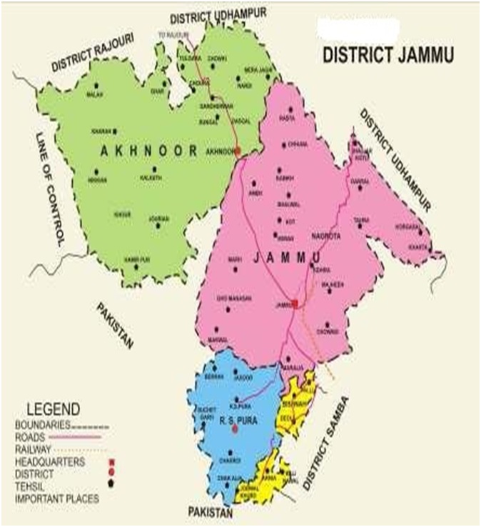
Map of the district Jammu
Population Density
As per the census of 2011, the
district has a population of 15.29
lakh. The average density of
population in the district as per
census of 2011 is 653 persons per sq
km. Schedule caste population in the
district is 3.78 lakh which works
out to be 24.71%of total population.
(census 2011)
Occupation Pattern
According to census of 2001 the
occupation pattern of the District
is such that the number or
Cultivators is 112480, Agriculture
Labourer is 24157, Business man 5848
and other 307718. The agriculture
labourer is about 25% of the total
working force.
Area Utilization
The total area of Jammu district is
2342 square kilometers (census
2011). In 2011-12, the net area sown
was 0.91 lakh hectare. Adding to it,
the area sown more than once which
was of the order of 0.951 lakh
hectare. The gross cultivated area
works out to be 1.857 lakh hectare.
Climate
Jammu District has a sub tropical
climate with hot and dry climate in
summer and cold climate in winter.
Being in the foothills of the
mountains, nights are generally
cooler that what they are in the
neighbouring areas of Punjab.
Minimum and Maximum temperature is
around 4oC respectively. Rainy
season usually starts from the end
of June or the beginning of July.
Average rainfall in the district is
about 1246 mm.
Irrigated Sub-Tropical Zone
It includes irrigated areas of
Satwari, Bishnah, R.S.Pura, Marh and
Bhalwal. The unirrigated area
fallsAkhnoor, Dansal and Khour
blocks.
Land use statistics (As per 2011
statistics)
|
1 |
Population |
15.29 lakh (as per census
2011) |
|
2 |
Area according to village
paper |
2.37 lakh ha |
|
3 |
Area under forests |
0.30 lakh ha |
|
4 |
Land put to non agricultural
use |
0.35 lakh ha |
|
5 |
Barrel and un cultivable land |
0.34 lakh ha |
|
6 |
Permanente pastures and
grossing |
0.04 lakh ha |
|
7 |
Cultivable waste land |
0.12 lakh ha |
|
8 |
Current follow |
0.17 lakh ha |
Data
as on 2011-12
|
Geographical Area (Sq.km)
a.
No of sub divisions
b.
No. of community development
blocks
c.
No. of villages |
2336
04
08
780 |
|
Agro climatic Zone |
Subtropical |
|
Agro climatic characteristics
a.
Temperature °C
Minimum
Maximum
b.
Rainfall (average in
mm)
c.
Humidity (highest in monsoon
month) |
4°C
47°C
1135 mm
90% |
Irrigation facilities from
different sources (ha)
|
S. No |
Source |
Area (ha) |
|
1 |
By Canal |
49886 |
|
2 |
By Well/Tubewell/others |
2405 |
|
3 |
Springs/Tanks |
1627 |
|
4 |
Others |
2161 |
|
Total irrigated area |
56079 (62%) |
Consumption of chemical fertilizers
(q) (Jammu + Samba)
|
Urea |
DAP |
MOP |
Total |
|
95603 |
63815 |
7350 |
160153 |
Animal population in the
district (as per 2011 census
in lacs)
|
Category |
Population (lakh) |
|
Cattle |
2.080 |
|
Buffalo |
1.615 |
|
Sheep |
0.600 |
|
Goats |
1.578 |
|
Horse & Ponies |
0.060 |
|
Donkeys/Mules |
0.010 |
|
Camels |
0.003 |
|
Pigs |
0.005 |
|
Poultry |
6.533 |
Predominant Economic Activities in
the District:
Paddy and Wheat
Major Food Commercial Crops of the
District:
Paddy, Maize, Vegetables, Wheat,
Pulses etc.
Existing Farming systems in
different blocks
|
S. No. |
Agro Ecological Situation |
Blocks |
Farming System |
|
1 |
(AES-I) |
R.S. Pura and Bishnah |
Agri + Animal Husbandry |
|
2 |
(AES-II) |
Marh and Satwari |
Agri + Vegetable +AH Horti |
|
3 |
(AES-III) |
Khour and Akhnoor |
Agri + Animal Husbandry |
|
4 |
(AES-IV) |
Bhalwal and Dansal |
Agri+AH+Horti+ Poultry |
Details of Crops and Cropping
Systems in the District
|
Season |
Crop |
AES-I |
AES-II |
AES-III |
AES-IV |
|
|
|
Cropping System |
Cropping System |
Cropping System |
Cropping System |
|
Kharif & Rabi |
Paddy - Maize |
Paddy - toria - wheat |
Paddy - toria - wheat |
Maize - toria - wheat
Maize - Patato - wheat |
Maize - toria - wheat
Maize - toria - Gobi sarson |
Description of Agro-climatic
Zone & major agro ecological
situations (based on soil and
topography)
|
S. No |
Agro-climatic Zone |
Characteristics |
|
1 |
Sub-tropical Zone |
Situated between 300-450m
above sea level having severe
winter, rare occurrence of
frost and a hot spell of
summer with concentration of
precipitation in summer months |
|
|
Agro ecological situation |
Characteristics |
|
2 |
Rain-fed |
The average rainfall of
District Jammu ranges between
750-900 mm. Agriculture in
this area is complex, diverse
and risk-prone and is
characterized by low levels of
productivity and low input
usage. Vagaries of the monsoon
result in wide variation and
instability in yields. |
Soil types of the district
|
S. No |
Soil type |
Characteristics |
|
1 |
Sandy loam |
pH 7.7-8.1, EC-0.15-0.23,
organic carbon 0.35-0.44
(low), N- low, P-medium, K-
medium |
|
2 |
Loamy sand |
pH 7.2-7.5, EC-0.15-0.20,
organic carbon 0.45-0.55
(low), N- low, P-medium, K-
high |
|
3 |
Clay loam |
pH 7.1-7.8, EC-0.18-0.22,
organic carbon 0.40-0.50(low),
N- low, P-medium, K- medium |
|
4 |
Silty clay loam |
pH 7.4-7.6, EC-0.16-0.20,
organic carbon 0.42-0.50
(low), N- low, P-medium, K-
medium |
Crop wise area sown under
different crops in Jammu
district
|
S. No |
Crop |
Season |
Unit |
Marh |
R.S. Pura |
Akhnoor |
Dansal |
Total |
|
1 |
Wheat |
Rabi |
Ha |
18450 |
21500 |
20350 |
10700 |
71000 |
|
2 |
Maize |
Kharif |
Ha |
4550 |
- |
3300 |
4150 |
12000 |
|
3 |
Paddy |
Kharif |
Ha |
12000 |
25000 |
7800 |
200 |
45000 |
|
4 |
Bajra |
Kharif |
Ha |
500 |
- |
2000 |
1000 |
3500 |
|
5 |
Pulses |
Kharif |
Ha |
1000 |
2350 |
1400 |
2000 |
6750 |
|
Rabi |
Ha |
1000 |
100 |
2200 |
1200 |
4500 |
|
6 |
Oilseed |
Kharif |
Ha |
800 |
- |
600 |
600 |
2000 |
|
Rabi |
Ha |
1100 |
1400 |
1500 |
700 |
4700 |
|
7 |
Fodder |
Kharif |
Ha |
800 |
600 |
600 |
500 |
2500 |
|
Rabi |
Ha |
2550 |
2500 |
2200 |
800 |
8050 |
|
8 |
Vegetables |
Kharif |
Ha |
1700 |
380 |
990 |
240 |
3310 |
|
Rabi |
Ha |
3320 |
1650 |
1480 |
240 |
6690 |
|
|
Sub Total: |
Kharif |
Ha |
21300 |
28330 |
16690 |
8690 |
75,010 |
|
|
Rabi |
Ha |
26470 |
27150 |
27730 |
13640 |
94,990 |
|
|
Total |
Ha |
47770 |
55480 |
44420 |
22330 |
170000 |
|

 Krishi
Vigyan Kendra Jammu
Krishi
Vigyan Kendra Jammu